Ready to embark on a mesmerizing adventure in the great outdoors? Look no further than Mount Tammany, where breathtaking views await you at every turn. This suggested hike will take you on a journey through stunning landscapes, captivating forests, and pristine trails. With its towering peaks and panoramic vistas, Mount Tammany promises an unforgettable experience for nature enthusiasts and hikers of all levels. Lace up your boots, grab your camera, and get ready to discover the awe-inspiring beauty of Mount Tammany.
Trail Overview
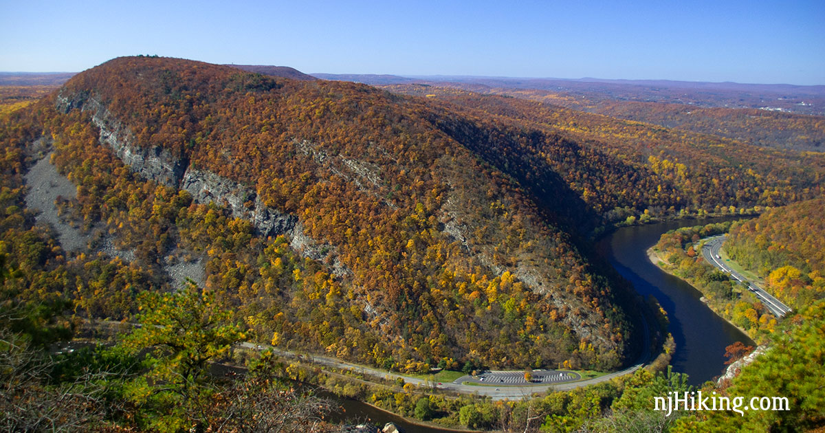
Mount Tammany offers a stunning hiking experience with its breathtaking views and diverse trail options. This trail is located in the Delaware Water Gap National Recreation Area, near the town of Columbia, New Jersey. The park is known for its lush forests, rushing rivers, and striking cliffs, making it a popular destination for outdoor enthusiasts. Whether you’re a seasoned hiker or just starting out, Mount Tammany has something to offer for everyone.
Length and Difficulty
The Mount Tammany trail is approximately 3.5 miles long, making it an ideal day hike for most individuals. The trail is rated as moderate to difficult, so it requires a reasonable level of fitness and stamina. With an elevation gain of over 1,200 feet, hikers will experience a challenging ascent. However, the trail is well-marked and does not require any technical skills or climbing equipment.
Scenic Highlights
One of the main highlights of the Mount Tammany hike is the panoramic views that await you at the summit. From the top, you can marvel at the stunning Delaware Water Gap and the surrounding mountains. On a clear day, you may even catch a glimpse of the New York City skyline in the distance. Additionally, the trail winds through scenic forests, allowing hikers to connect with nature and enjoy the peacefulness of the area.
Trail Map
Before embarking on your Mount Tammany adventure, it’s essential to familiarize yourself with the trail map. You can find maps online or at the Delaware Water Gap National Recreation Area visitor center. The map will help you understand the different trail options, locate parking areas, and identify any points of interest along the way. Carrying a physical or digital copy of the map is crucial for navigation and ensures a safe and enjoyable hike.
Preparing for the Hike
To make the most of your Mount Tammany hike, proper preparation is key.
What to Bring
When packing for your hike, remember to bring essentials such as sturdy hiking boots, a comfortable backpack, and plenty of water. Layered clothing is recommended as the temperature can vary throughout the day. Additionally, consider bringing a hat, sunglasses, sunscreen, and insect repellent to protect yourself from the elements. Snacks or a packed lunch are also a great idea to keep your energy levels up during the hike.
Weather Considerations
The weather on Mount Tammany can change rapidly, so it’s important to check the forecast before your hike. Rainy conditions can make the trail slippery and muddy, while extreme heat can increase the risk of dehydration and heatstroke. Dress appropriately for the weather forecast and be prepared to adjust your plans if needed. It’s always better to be safe than sorry when it comes to weather conditions.
Permits and Fees
To access the Mount Tammany trail, you may need to obtain a permit or pay a fee. The Delaware Water Gap National Recreation Area requires visitors to purchase a day pass or have an annual pass. These passes help maintain and preserve the park’s natural beauty. Be sure to check the current permit and fee requirements before your hike to avoid any issues or delays.

Trailhead and Parking
Finding the trailhead and securing parking are essential steps in starting your Mount Tammany hike.
Location
The trailhead for Mount Tammany is located in the Delaware Water Gap National Recreation Area, near Columbia, New Jersey. When heading to the trailhead, it’s recommended to use GPS or navigate using a detailed map to ensure you arrive at the correct location. The park is easily accessible by car and is located within a reasonable distance from major cities in the region.
Parking Availability
Parking at the Mount Tammany trailhead can be limited, especially during peak times such as weekends and holidays. It’s advisable to arrive early to secure a parking spot. If the designated parking area is full, park in alternative locations as directed by park staff or signage. As always, be mindful of parking regulations and do not block any access roads or emergency routes.
Trailhead Facilities
The Mount Tammany trailhead offers limited facilities, so it’s important to come prepared. There are restrooms available near the parking area, but they may not always be well-maintained. It’s recommended to use the restroom facilities before arriving at the trailhead if possible. There are no food or water vendors at the trailhead, so ensure you have enough provisions to sustain you throughout your hike.
Hiking Route Options
Mount Tammany offers three main hiking route options, each with its own unique characteristics and attractions. You can choose to hike the Red Dot Trail, the Blue Dot Trail, or combine both for a longer and more challenging adventure.
Red Dot Trail
The Red Dot Trail is the most popular route up Mount Tammany. It starts near the Dunnfield Creek parking area and ascends steeply through the forest. This trail offers a more direct and strenuous path to the summit. As you hike, you’ll encounter rocky terrain and a series of switchbacks, showcasing the area’s natural beauty. The Red Dot Trail is approximately 1.5 miles long and is marked with red dots to guide you along the way.
Blue Dot Trail
The Blue Dot Trail is an alternative route to reach the summit of Mount Tammany. This trail starts from the same parking area as the Red Dot Trail but takes a longer and more scenic route. The Blue Dot Trail is approximately 2.5 miles in length and offers a more gradual ascent. Along the path, you’ll be treated to picturesque views of the Delaware River and the surrounding landscape. The trail is marked with blue dots, making it easy to follow.
Combining Both Trails
For those seeking a longer and more challenging hike, combining both the Red Dot Trail and the Blue Dot Trail is a fantastic option. By starting on the Red Dot Trail and descending on the Blue Dot Trail, you’ll experience the best of both worlds. This combined route is approximately 3.5 miles long and allows you to appreciate the diverse scenery that Mount Tammany has to offer.

Red Dot Trail
The Red Dot Trail is a thrilling and rewarding way to reach the summit of Mount Tammany. Lace up your hiking boots and get ready for an adventure.
Trail Description
The Red Dot Trail starts near the Dunnfield Creek parking area and begins with a steep climb. As you ascend, you’ll navigate through rocky terrain and lush vegetation. The trail is well-marked with red dots, ensuring that you stay on the right path. Follow the switchbacks and keep an eye out for scenic vistas along the way. As you near the summit, the trail becomes more challenging, requiring careful foot placement and agility.
Points of Interest
Throughout the Red Dot Trail, you’ll encounter several points of interest that add to the allure of the hike. Look out for hidden waterfalls, impressive rock formations, and captivating wildlife. Take a moment to appreciate the sounds of nature and the tranquility that surrounds you. Once you reach the summit, be prepared to be awe-struck by the expansive views of the Delaware Water Gap and the surrounding landscape.
Difficulty Level
The Red Dot Trail is rated as a moderate to difficult hike. Its steep incline and rocky terrain present challenges that require a reasonable level of fitness and agility. Hikers should be prepared for a strenuous ascent and be mindful of their footing on the sometimes slippery trail. While the trail may be challenging, the sense of accomplishment and the stunning views at the summit make it all worthwhile.
Blue Dot Trail
If you prefer a more gradual and scenic climb, the Blue Dot Trail is an excellent choice.
Trail Description
The Blue Dot Trail shares the same starting point as the Red Dot Trail, near the Dunnfield Creek parking area. However, instead of ascending steeply, the Blue Dot Trail takes a longer and more leisurely path to the summit of Mount Tammany. This trail winds through beautiful forests, crosses streams, and offers occasional glimpses of the surrounding landscape. The blue dots painted along the trail serve as markers, keeping you on track throughout your journey.
Points of Interest
As you hike along the Blue Dot Trail, you’ll encounter numerous points of interest that showcase the natural beauty of the area. Look out for the stunning views of the Delaware River from certain vantage points along the trail. Take a moment to appreciate the peacefulness of the forest and the melodies of the birds that call this area home. The Blue Dot Trail allows you to immerse yourself in nature and enjoy a more relaxed hiking experience.
Difficulty Level
The Blue Dot Trail is rated as a moderate hike, making it suitable for hikers of various skill levels. While the ascent is more gradual compared to the Red Dot Trail, there are still some uphill sections that require a moderate level of fitness. The trail is well-marked and maintained, ensuring a pleasant hiking experience. Whether you’re a beginner hiker or simply prefer a less strenuous climb, the Blue Dot Trail offers a delightful way to reach the summit of Mount Tammany.

Combining Both Trails
For hikers looking for a longer and more challenging adventure, combining the Red Dot Trail and the Blue Dot Trail is an excellent option.
Trail Description
To combine both trails, start on the Red Dot Trail near the Dunnfield Creek parking area. Follow the steep ascent and enjoy the rocky terrain and switchbacks along the way. Once you reach the summit, take in the panoramic views before descending on the Blue Dot Trail. This trail offers a more gradual descent, allowing you to appreciate the scenery at a leisurely pace. Follow the blue dots and enjoy the serenity of the forest as you make your way back to the trailhead.
Points of Interest
By combining both trails, you’ll have the opportunity to experience the highlights of both the Red Dot and Blue Dot Trails. Marvel at the breathtaking views from the summit of Mount Tammany and appreciate the diverse flora and fauna along the trails. Keep an eye out for unique rock formations, hidden waterfalls, and the occasional wildlife sighting. Every step of the way offers a new discovery and a chance to connect with nature.
Difficulty Level
Combining both the Red Dot Trail and the Blue Dot Trail adds an extra level of difficulty to the hike. The overall length of approximately 3.5 miles and the continuous ascent and descent require a good level of endurance and fitness. Be prepared for a longer journey and ensure you’re adequately prepared with proper hiking gear and provisions. The combined trail offers a thrilling adventure for experienced hikers seeking a challenge.
Recommended Hiking Gear
To ensure a safe and enjoyable hike, it’s essential to have the right gear for your Mount Tammany adventure.
Hiking Boots
Investing in a pair of sturdy and comfortable hiking boots is crucial for tackling the varied terrain of Mount Tammany. Look for boots with ankle support and a good grip. Properly fitted boots will help prevent blisters and provide stability on uneven surfaces. Break in your boots before your hike to avoid discomfort or injuries on the trail.
Backpack
A reliable backpack is essential for carrying your essentials during the hike. Choose a backpack that is comfortable to wear and has enough capacity to hold extra layers, food, water, and any other gear you may need. Look for a backpack with adjustable straps and padding to ensure a proper fit and minimize strain on your shoulders and back.
Water and Snacks
Staying hydrated and energized is crucial during your Mount Tammany hike. Carry an adequate amount of water to keep yourself hydrated throughout the journey. Consider using a hydration bladder or carrying water bottles in your backpack. Additionally, pack snacks such as energy bars, trail mix, or fresh fruit to keep your energy levels up during breaks.

Safety Tips
While hiking Mount Tammany can be a thrilling adventure, it’s important to prioritize your safety. Follow these safety tips to make the most of your hiking experience.
Stay on Marked Trails
It’s crucial to stay on the marked trails throughout your hike. Straying off the designated paths can lead to getting lost or causing environmental damage. Follow the red or blue dots, depending on the trail you choose, and avoid any shortcuts or unmarked routes. The trails are well-maintained and take you safely to your destination.
Watch Your Step
Mount Tammany’s trails can be rocky, uneven, and sometimes slippery, especially after rain. Always watch your step and be mindful of your footing. Take your time when descending or ascending steep sections to avoid tripping or slipping. Consider using trekking poles for added stability, especially during challenging parts of the trail.
Use Sun Protection
The sun can be intense, even in shaded areas of the trail. Protect yourself from harmful UV rays by wearing sunblock, sunglasses, and a hat. Additionally, consider wearing lightweight, breathable clothing that provides coverage without overheating. Take breaks in shaded areas when needed to rest and rehydrate.
Conclusion
Now that you have all the information you need, it’s time to embark on your Mount Tammany adventure. Enjoy the spectacular views, breathe in the fresh air, and immerse yourself in the beauty of nature. Whether you choose the Red Dot Trail, the Blue Dot Trail, or a combination of both, Mount Tammany offers an unforgettable hiking experience. Plan your next hike to this picturesque destination and create memories that will last a lifetime.
